Current INL Observations
Click
for all observations.
Current Warnings
Arco/Mud Lake Desert (NWS)
Current Conditions
INL Observations
INL Wind Trends
Top Wind Gusts
Profiler Wind Plot
Surface Map
SE Idaho Radar
Satellite Images
INL Lightning Map
(INL Only)
INL Camera
ID Road Conditions
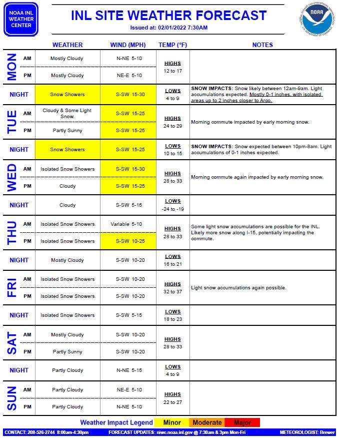
Forecasts
INL Forecast
Idaho Falls (NWS)
Southeast Idaho (NWS)
Fire Weather (NWS)
Weather Models
Storm Prediction Center
Climate
INL
Local (NWS)
Climate Prediction Center
NOAA INL Mesonet
Daily Summary
Data Extractor
Precipitation Summary
Windfield Display
Weather Safety
Weather Radio
Winter Safety
Flood Safety Tips
Summer Safety
Lightning Safety
Storm Ready
INL Wind Safety
About SORD
About SORD
SORD Projects
SORD Handout
SORD Contact
Other Links
NWS Home Page
NWS Pocatello
Fort St. Vrain
Contact:
INL weather questions
phone: 526-2744
email
7-DAY INL FORECAST
Click below for latest forecast.
WINDS
Click below for latest INL winds.
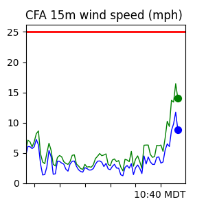
6-HR CFA WIND TREND
Click below for larger image.
RADAR
Click below for larger image.
Radar Display
SATELLITE
Click below for more images.
Satellite Loop
INL ITD CAMERA
Click below for larger image.
Sunrise/Sunset
Top Wind Gusts
Current Conditions
Daily Summary
Precip Summary
INL Lightning
INL Climate
This page automatically refreshes every 5 minutes.
Modified: March 22, 2017
Dept. of Commerce
|
NOAA
|
NOAA Research
|
ARL
|
SORD-ID
Privacy
|
Disclaimer
|
Information Quality
|
webmaster